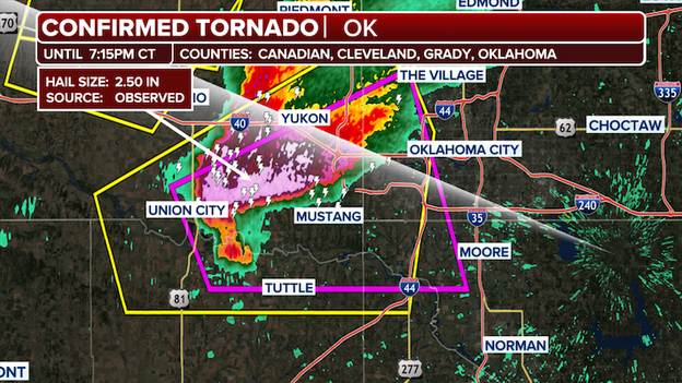
How to Track Oklahoma Tornado Warnings with Live Radar Updates
When a thunderstorm rolls across the plains, the difference between watching a screen and staying inside can be a matter of minutes. Oklahoma tornado warnings live radar updates give you that crucial window, turning raw data into a clear picture of what’s swirling overhead. In this guide we’ll walk through the main radar platforms, the signatures to watch for, and practical steps to keep yourself and your family safe when the sirens start wailing.
Why Live Radar Matters for Oklahoma Tornado Warnings
Oklahoma sits in the heart of Tornado Alley, where supercells can spin up with alarming speed. Traditional forecasts are valuable, but they often lag behind the storm’s actual motion. Live radar, refreshed every minute or even every few seconds, shows the storm’s core, its rotation, and how quickly it’s moving. That immediacy helps local National Weather Service (NWS) offices issue warnings faster, and it gives residents the chance to react before the funnel touches ground.
Top Radar Sources You Can Trust
Not all radar feeds are created equal. Here are the most reliable options for real‑time tracking:
- NWS Storm Prediction Center (SPC) Radar – The official source, offering a clean, unfiltered reflectivity view plus velocity data that highlights rotation.
- RadarScope (app) – A paid app favored by storm chasers, it delivers Level III NEXRAD data with customizable overlays.
- Weather Underground’s Radar Map – Free and web‑based, it adds community alerts and a simple “tornado threat” color scheme.
- MyRadar (mobile) – Easy to read, it pushes push‑notifications the moment a warning is issued for your coordinates.
Pick the one that matches your tech comfort level; the key is to have it open whenever severe weather is on the horizon.
How to Read the Radar Signs of a Tornado
Even a casual observer can spot the red flags that forecasters rely on. Look for these three visual cues:
- Hook Echo – A classic “U” shape on reflectivity, indicating a mesocyclone turning toward the ground.
- Velocity Couplets – Adjacent red and green bars on the velocity pane, showing air moving toward and away from the radar at high speeds.
- Debris Signature (DP) – A compact, high‑reflectivity blob on the lowest radar sweep, often confirming a tornado on the ground.
When any of these appear, the radar will usually flash a tornado warning icon. That’s the moment to act.
Setting Up Real‑Time Alerts
Most radar apps let you define a geographic radius for alerts. Here’s a quick setup checklist:
- Enable push notifications for tornado warnings.
- Turn on audible alerts, not just visual pop‑ups.
- Set the alert radius to at least 20 miles if you live in a rural area, because storms can travel fast.
- Sync the app with your phone’s emergency alerts (e.g., Wireless Emergency Alerts in the U.S.).
Testing the alert sound before a storm hits ensures you won’t miss it when the siren blares.
What to Do When a Warning Hits
Having a plan can shave precious seconds off your reaction time. Follow these steps:
- Take shelter immediately. Head to a basement, storm cellar, or interior room on the lowest floor, away from windows.
- Gather essential items. A flashlight, a battery‑powered radio, and a small emergency kit should be within arm’s reach.
- Stay informed. Keep the radar feed open, but also listen to local radio or the NWS website for updates on the warning’s status.
- Don’t assume the danger is over. Tornadoes can spawn multiple vortices; stay inside until the warning is officially lifted.
Common Misconceptions About Radar Warnings
People sometimes think a radar “miss” means no danger, or that a “watch” is the same as a “warning.” In reality, a watch signals conditions are favorable for tornadoes, while a warning means one has been spotted or is imminent. Also, radar can be blocked by terrain; if you’re in a valley, keep an ear out for sirens and neighbor reports even if the screen looks clear.
Staying Prepared Year‑Round
Oklahoma’s tornado season runs from late spring through early summer, but severe storms can appear any time. Make radar monitoring a habit:
- Check the forecast each morning during peak months.
- Mark your family’s safe room on a floor plan.
- Practice “drop, cover, and hold on” drills with kids.
Regular readiness reduces panic and improves your response when the live radar finally lights up with a warning.
FAQ
How often is live radar data refreshed?
Most public radar sites update every 5 minutes, while premium apps like RadarScope can show updates as frequently as every 30 seconds for certain areas.
Can I rely solely on my phone’s emergency alerts?
Phone alerts are essential, but they sometimes lag behind the radar. Using a dedicated radar app as a backup gives you a visual confirmation of the storm’s path.
What does a “tornado emergency” mean?
A tornado emergency is an enhanced warning issued when a large, destructive tornado is expected to hit a densely populated area. It signals the highest level of threat and calls for immediate shelter.
Are there any free radar sources that include velocity data?
Yes. The NWS’s official radar page provides both reflectivity and velocity layers at no cost, though the interface is more technical than consumer‑focused apps.